
We provide high quality products, new and used industrial and medical equipment at very reasonable costs.
We provide high quality products, new and used industrial and medical equipment at very reasonable costs.
We provide high quality products, new and used industrial and medical equipment at very reasonable costs.
Showing 25–36 of 39 results
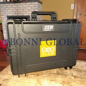
GeoSLAM ZEB HORIZON 3D Laser Scanner Includes: ZEB Horizon Scanner, ZEB Horizon data logger with shoulder strap (incl. 14.8V battery), 14.8V Battery Charger, ZEB Horizon main cable (1.5m length), USB memory stick, Reference base, Shipped in a soft carry case, GeoSLAM Connect software (Not Included with Open Box Products) and 3-year hardware warranty when a valid GeoSLAM Care package is in place.
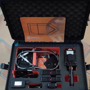
GeoSlam ZEB REVO RT Handheld Laser Scanner includes: GS_610042 Geoslam ZEB-REVO handheld laser scanner, GS_610070 Geoslam ZEB-REVO RT Processing Unit, GS_610008 Geoslam ZEB REVO main cable, PAG_9307V ZEB-REVO RT battery, PAG_ 9710 ZEB-REVO RT battery charger, MUS_40_1_5 Shoulder strap, RS_832-347 Ethernet cable, GS_610073 ZEB-CAM cable (compatible with RT Processing Unit), GS_510072 Heavy Duty Carry case,
GS_SW_LICENSE GeoSLAM HUB license dongle and USB memory stick, GS_610071 Magnetic mount for tablet or cell phone, Backpak and 1 year hardware warranty.
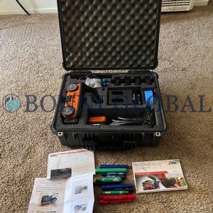
GSSI StructureScan Mini XT concrete Inspection Includes: All-in-one Control Unit, 2700 MHz antenna and survey wheel combo, Lithium-ion battery (2), Dual bay battery charger, Rugged transit case, Quick Start Guide, Sample 3D data collection grid pack, 2 year warranty and RADAN 7 Software License for StructureScan Mini.
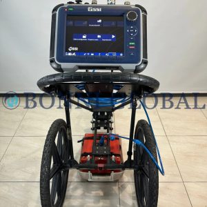
GSSI StructureScan Pro SIR 4000 Control Unit includes: SIR 4000 Control Unit, 1600 MHz or 2600 MHz antenna, Model 615 handcart with encoder, 7 meter control cable, 2x Lithium-ion battery (Dual-bay battery charger), Rugged transit case, 2 year warranty, RADAN 7 Software, Accessories (Palm Antenna, SIR 4000 stand, SIR 4000 carry harness) and 3 years GSSI warranty.
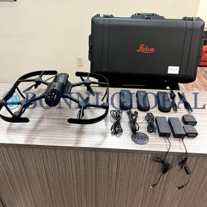
The Leica BLK2FLY is a groundbreaking autonomous flying laser scanner that revolutionizes the way we capture and analyze spatial data. This innovative device combines advanced scanning technology with the freedom of flight, allowing it to effortlessly navigate complex environments and gather precise 3D measurements from above. With its lightweight design and intelligent flight capabilities, the BLK2FLY can operate in challenging locations where traditional ground-based scanners may struggle, making it an invaluable tool for architects, engineers, and surveyors.
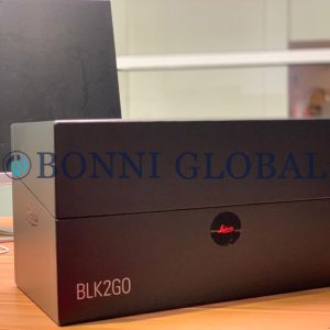
The Leica BLK2GO Handheld Imaging Laser Scanner drastically reduces the time needed to plan and scan on-site, and it doesn’t need a tripod or a trained operator. The BLK2GO is wireless and lightweight, designed to capture reality on the move, anywhere you go.

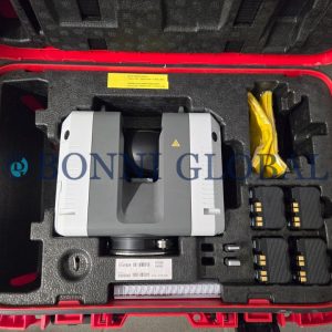
Leica BLK360 G2 Imaging Laser Scanner Package includes: BLK360 G2 Laser Scanner, GVP739 Transportation Case, (3) GEB825 Batteries, GKL825 Multicharger, GEV278 USB Cable and BLK Cleaning Cloth.
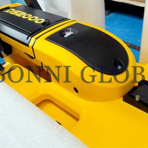
The Leica DS2000 Utility Detection Radar effortlessly detects and positions both shallow and deep targets simultaneously, gathering more information, quicker, in any environment. Data collection and export of underground utilities, from storm sewers to fibre optics, is possible with the Leica DS2000.
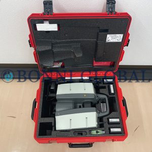
The Leica RTC360 3D Laser Scanner utilizes a unique reality capture solution that empowers users to document and capture their environments in 3D. This scanner improves efficiency and productivity in the field and in the office through fast, accurate, portable, and simple-to-use hardware and software.
Leica ScanStation P40 3D Laser Scanning deliver highest quality 3D data and High-Dynamic Range (HDR) imaging at an extremely fast scan rate of 1 million points per second at ranges of up to 270m. Unsurpassed range and angular accuracy paired with low range noise and survey-grade dual-axis compensation form the foundation for highly detailed 3D colour point clouds mapped in realistic clarity.
Stonex R80 Motorized Total Station is a Motorized Total Station for classic jobs for survey and stakeout and perfect for high precision surveying areas, such as rail traffic monitoring, control of structures, bridges, dams and landslide areas.
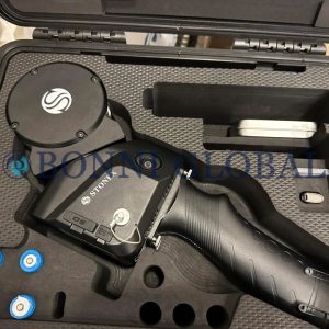
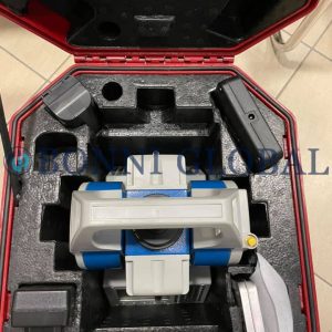
Stonex X120GO Slam 3D Scanner, a powerhouse for accurate and versatile point cloud data collection. Featuring a 360° rotating head, this system provides unparalleled coverage, generating a 360° x 270° point cloud without the need for light or GPS. The industry-standard SLAM algorithm ensures highly accurate three-dimensional data capture in any environment.